Marine Way Undercrossing

Monday, February 2, 2026

Timeline & Current Construction | FAQs

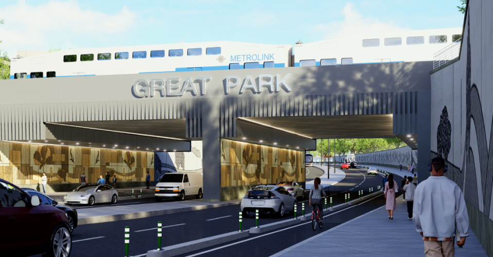
The City of Irvine is advancing the Marine Way extension and undercrossing to improve access and traffic circulation in and around the Great Park. While Marine Way runs along the southern edge of the park, there is currently no direct rail crossing or direct road access into the Great Park from Marine Way and Barranca, where Marine Way currently ends.

The project will create a new rail undercrossing at Marine Way, providing a direct connection between the Great Park and the Spectrum area — the nearest crossings are currently located at Sand Canyon Avenue and Alton Parkway. The Marine Way road extension will connect the two existing termini of Marine Way at the Great Park, and Marine Way and Barranca. These new routes will reduce travel distances, ease congestion, and help save time and fuel for drivers.

Once complete, the project will enhance safety for pedestrians and bicyclists, support walking and biking with new connections, and reduce greenhouse gas emissions by cutting down on vehicle trips.

Construction is underway, with major work continuing through 2026 and full project completion anticipated in 2027.


Watch the Marine Way Undercrossing Visualization.

View the Fact Sheet.

Timeline & Current Construction 

March-May: Construction is underway on the Borrego Channel tunnel structure  — a waterway that currently runs north of the train tracks. As Marine Way is extended to create a new rail undercrossing, the channel will be rerouted through this new structure. 

May-September 2026: The Marine Way underpass tunnel structure will be constructed, which will serve vehicles, pedestrians, and cyclists. 

For more details visit greatparkframework.org

FAQs

Questions & Answers

Bike Safety & Design

Q: Will the project include protected or separated bike lanes, beyond standard painted striping?
A: Yes.

Q: Will there be physical separation (such as curbs, barriers, or railings) between bicyclists and vehicle traffic?
A: Yes. A raised concrete bike separator for the on-street bike lanes and a curb and slope protecting the off-street shared bicycle/pedestrian trail.

Q: Can the bike facilities be widened or designed as a separate paved path to improve safety?
A: The Marine Way Grade Separation (Project) includes an 11 ft. wide off-street Class I trail.

Q: If improving safety for cyclists is a project goal, why does the current rendering not depict protected bike lanes?
A: The walking trail depicted in the renderings is an 11 ft. wide off-street Class I trail, and is available to cyclists.

Transit & Access

Q: Will there be transit access from the train station for individuals traveling to the Great Park without a vehicle?
A: The project could allow for future transit opportunities. At this time, no routes are planned.

Q: Will the project provide Metrolink access from the Marine Way / Great Park side?
A: When construction of the Project is complete, individuals can cross under the railroad tracks at Marine Way and travel ¼ mile NW on Barranca Parkway to the Irvine Transportation Center.

Q: Will there be Amtrak access from the Marine Way / Great Park side, or will rail access remain limited to Barranca?
A: Rail access will remain limited to Barranca Parkway after the project is complete, however the City is looking into an additional railroad crossing at Ada (Irvine Transportation Center).

Q: Is this project coordinated with existing or planned transit services?
There are no OCTA or City plans to extend or reroute existing service as a result of the project, and no plans to expand service into the Great Park.
 

Traffic & Road Connectivity

Q: Will the project include improvements to reduce congestion at Sand Canyon and Marine Way near the I-5 Freeway?
A: Yes. The Project will reduce congestion on Sand Canyon and Alton Parkway by adding an additional access point to the Great Park.

Q: Will the merging lanes on Sand Canyon be redesigned to improve safety and traffic flow?
A: Merging lanes on Sand Canyon will remain as-is until the Sand Canyon/Marine Way intersection is ultimately realigned.

Q: Should Marine Way be expanded to additional travel lanes to accommodate future growth?
A: The proposed four-lane undercrossing will connect to the existing four-lane Marine Way to the south and the planned four-lane Marine Way to the north. The four-lane capacity is anticipated to accommodate the future growth of the city. The roadway network, including this project, has been designed and built to accommodate these growth assumptions.

Q: Will the other end of Marine Way be addressed in a future phase?
A: The other segments of Marine Way are currently under construction by Fivepoint. The road will be opened to the public when construction is completed and accepted by the City.

Q: Is Ridge Valley planned to be extended to Technology Drive?
A: The County owns the property along south side of Marine Way at Ridge Valley. There is no plan to extend Ridge Valley to the south at this time.

Q: Can Marine Way be opened between Alton Parkway and Bake Parkway at this time? If not, what is preventing it from opening?
A: Marine Way will be opened to the public as soon as the remaining traffic signal work is complete and the signals are fully operational.

Environmental & Community Considerations

Q: How is the project addressing environmental impacts, including loss of green space and urban development concerns?
A: The project reduces vehicle trips and miles traveled, cutting greenhouse gas emissions and improving air quality and quality of life.

Q: How does this project align with the vision of the Great Park as a public open space and community asset?
A: The project will improve accessibility to the Great Park.

Q: Has the City evaluated visibility and lighting conditions, including transitions between light and dark areas?
A: Yes. Site distance and lighting photometrics were considered in the design.

Q: Will the design include accessible features and accommodations for individuals with disabilities?
A: Yes. The features designed are ADA-compliant.
 

Project Scope, Timeline & Priorities

Q: Will the City provide a project map or diagram showing the full alignment and connections?
A: Refer to OCTA’s 2025 Master Plan of Arterial Highways.

Q: What is the anticipated timeline for project completion?
A: Completion of the Project is scheduled for April 2027. Completion of Marine Way within the Great Park and connection to the Marine Way Grade Separation is anticipated summer of 2027.

Q: Will the project be delivered within a reasonable timeframe, or is it a longer-term effort?
A: Due to the nature of the Project’s construction (built on site and slid into place), the construction duration is shorter than typical grade separation projects.

Q: Why is this project being prioritized at this time compared to other infrastructure needs?
A: The Project is necessary to mitigate traffic congestion within and around the Great Park.

Q: How does this project relate to upcoming regional events and long-term planning efforts?
A: The roadway and resulting project have been previously assumed and analyzed in the City’s General Plan and the County’s Master Plan of Arterial Highways. As a result, all planning and environmental approvals, including analysis of traffic, have included the project, and all planned regional and city growth is assumed to occur.

Q: We heard there are three stages for this project. Can you outline what the stages are?
A: In general, the Project consists of constructing and installing the Borrego Channel structure, realigning the existing Borrego Channel through the new structure, constructing and installing the Marine Way Grade Separation structure, and lastly, realigning existing Marine Way through the new structure. Keep in mind that work on these components can occur at the same time, but cannot be finished until the previous is completed.

Q: Can you also share any scope modifications that have occurred recently?
A: There haven’t been any recent project scope modifications.

Q: Is there a timeline for when the train tracks will be closed during construction?
A: Yes. Metrolink provided a calendar with allowable 53-hour Absolute Work Windows (AWWs). Installation of the Borrego Channel structure is scheduled during a May 16-18, 2026 AWW. Installation of the Marine Way structure is scheduled during a September 12-14, 2026 AWW.

Q: I heard this is not a common construction practice on the West Coast. Is that correct, and if so, why?
A: Correct. Typically, grade separations are constructed by rerouting railroad tracks around the work area, constructing the new grade separation structure, and then restoring the original track alignment. The Marine Way Grade Separation structure will be constructed on site and moved into place during a 53-hour railroad shutdown, eliminating the need to construct and remove temporary tracks.

Transparency & Governance

Q: How is the City ensuring the project is cost-effective, transparent, and responsibly managed?
A: The Project was competitively bid in accordance with the California Public Contract Code, awarded to the lowest responsive/responsible bidder, and is responsibly managed by City staff and qualified consultants.

Q: What is the overall long-term vision for mobility and access at the Great Park?
A: The Great Park Framework Plan, adopted in 2023, incorporates a strategic network system of both vehicular roads and multimodal trails and pedestrian pathways. Roadways include multiple park entry and internal circulation routes, as well as the inclusion of multiple grade-separated pedestrian bridges. Pedestrian-oriented trail and pathways traverse multiple Framework Plan sectors, connecting various programming centers and amenities.