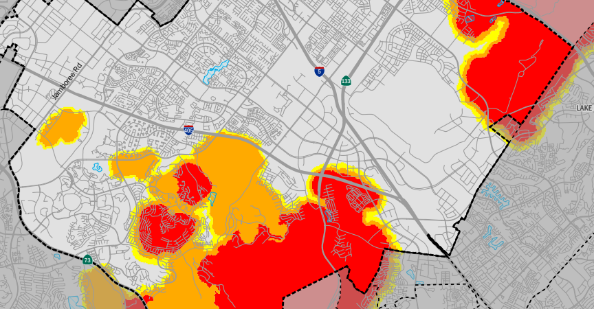
In March 2025, the California Office of the State Fire Marshal (OSFM) released its updated 2025 Local Responsibility Area Fire Hazard Severity Zone (FHSZ) Map. The City of Irvine adopted this map without amendment by ordinance in June 2025, replacing the 2012 map, and it became effective July 23, 2025. The updated map classifies FHSZ as Moderate (yellow), High (orange), and Very High (red) and reflects expanded fire hazard zones into Orchard Hills, Woodbury, Portola Springs, Quail Hill, Turtle Rock, Laguna Altura, Los Olivos, and Irvine Spectrum based on the latest wildfire modeling, climate data, and topography.
New construction or major renovations with permit application dates after the effective date date must comply with building and fire code requirements where projects are located in 2025 FHSZ areas. Projects submitted before the effective date remain subject to the 2012 map areas.
Fire Hazard Severity Zone Map
2025 Fire Hazard Severity Zone PDF Map
2025 Fire Hazard Severity Zone Interactive Map
2011 and 2025 Fire Hazard Severity Zone Interactive Comparison Map
Public Input
Working together for a safer Irvine: The City has made the State Fire Marshal's Fire Hazard Severity Zone map available for public review and comment, as required by California Government Code 51178.5. We invite all community members to explore this map and contribute their local knowledge through the public comment portal(link is external).
More Information
CAL FIRE's Fire Hazard Severity Zone Website
For additional information about the Fire Hazard Severity Zone map or the adoption process, please contact cd@cityofirvine.org(link sends e-mail).

